ORLANDO, Fla. — As anticipated earlier this summer, La Niña had a good chance of making its appearance just in time for the peak of hurricane season. On Thursday morning, the National Oceanic and Atmospheric Administration (NOAA) officially declared that we are in a La Niña phase.
La Niña is a weather pattern that occurs over the eastern Pacific, but it has worldwide effects. Specifically, for the Atlantic Basin, if there is a La Niña present during hurricane season, more tropical systems tend to develop (we´ve already seen record formations so far this season).
Enhanced tropical formations happen because, under a La Niña, there is weaker vertical wind shear, trade winds, and more instability over the Atlantic.
On the other ocean, sea surface temperatures tend to be cooler over the eastern Pacific and stronger wind shear which causes less tropical systems to form.
La Niña is not something that is forecast like your daily weather forecast. There are conditions that can help scientists determine if there is a possibility for La Niña to develop. But in order to be declared, certain conditions must be met.
LATEST: EYE ON THE TROPICS
Let´s review those conditions
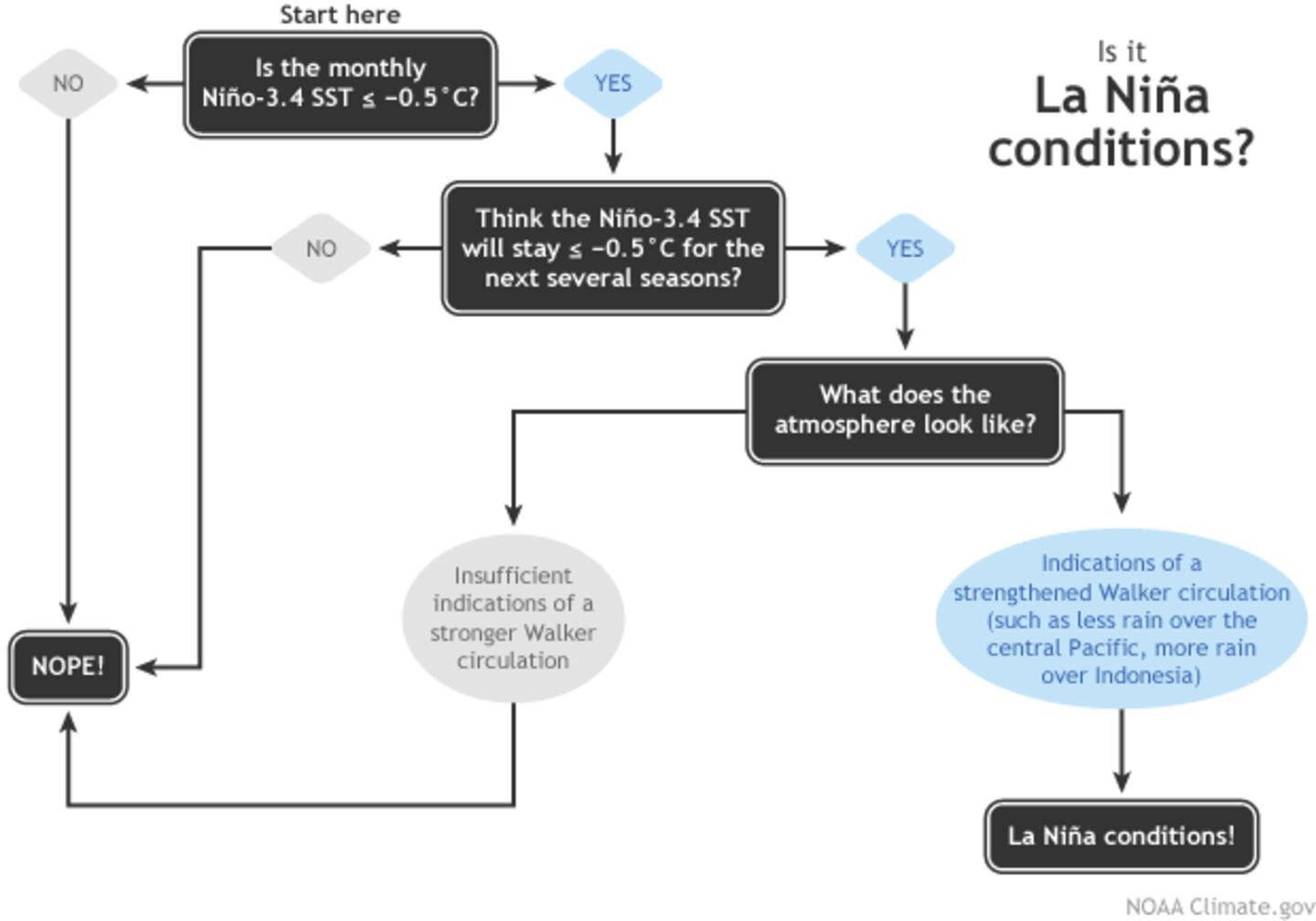
First, the monthly sea surface temperature anomaly must be equal to or less than -0.5C. Then scientists look for other atmospheric conditions, such as the Walker circulation. This is an atmospheric pattern that brings less rain over the central Pacific and rainier weather over Indonesia.
In the last weeks, scientists have observed a stronger Walker circulation, and the temperature anomaly was -0.6C in August.
Scientists have been observing the gradual downslope trend of the sea surface temperature anomaly since April 2020.
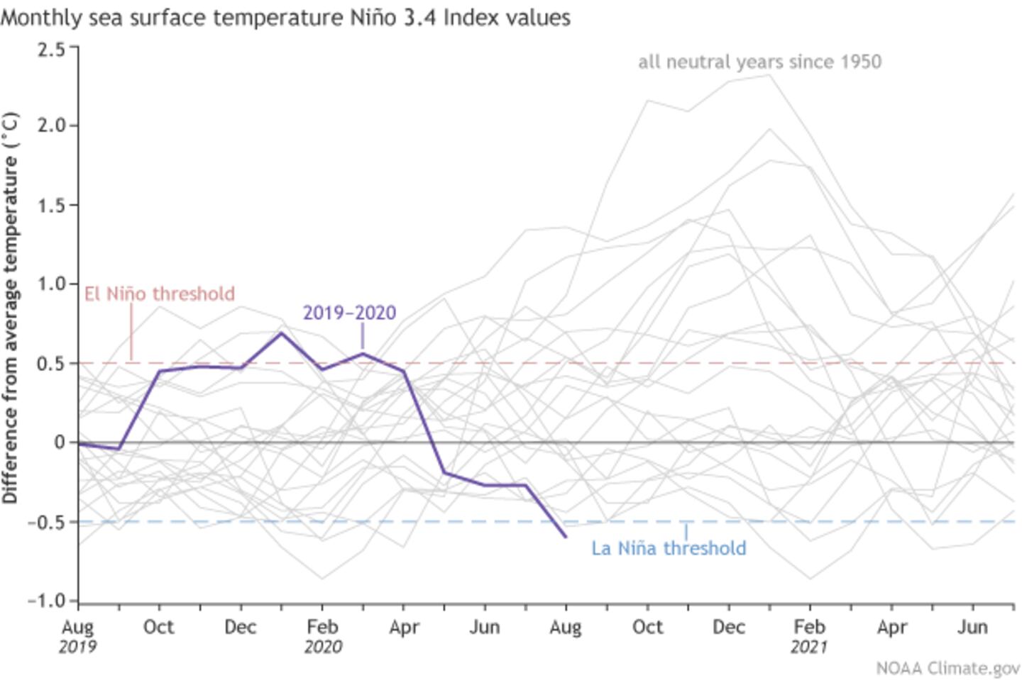
Then scientists need to forecast how likely it is for the temperature anomaly to continue for the next several months. They use models to predict that the sea surface temperature anomaly will continue to be below the -0.5C mark through the winter. In fact, the forecast calls for the temperature anomaly to stay below the threshold until March 2021.
The contrast in temperatures between the warm western Pacific and the much cooler Pacific is what drives to a strengthening Walker circulation.
La Niña is (officially)here! The active Atlantic was already telling us so! 😏
— Irene Sans (@IreneSans) September 10, 2020
And it will likely stay through the winter. Not good news for #California. Read more here: https://t.co/mWCE8WjmFN pic.twitter.com/xSMYOBcQZY
Just as in any other region, warmer water temperatures lead to rising air. The air rises over the western Pacific and travels eastward high in the atmosphere, sinking over the eastern Pacific. Once the air sinks, it travels back to the west closer to the surface. When this huge air circulation is stronger than normal, there are higher trade winds and sinking air over the eastern Pacific, just inhibits tropical storm formation greatly.
La Niña in the U.S. during the winter months
Since la Nina is forecast to stay through the winter months, it is important to highlight that it can also bring big shifts to weather patterns for the U.S.
When La Niña conditions are present in the winter, the polar jet stream tends to shift to the north, which brings wetter and cooler conditions for the northern half of the continental U.S. For the southern half, including California all the way east to Florida, the weather tends to be warmer and drier. This is not great news for California. Although it doesn´t mean California will not get any rain in the winter, it does give them a higher chance for the extreme drought conditions to continue. This drought is playing a huge role in the recent fires.
Read more: Update: NOAA’s Hurricane season forecast predicts a record number of storms this season
VISITE NUESTRA SECCIÓN EN ESPAÑOL SOBRE EL TRÓPICO
DOWNLOAD OUR FREE WFTV WEATHER APP TO RECEIVE ALERTS
Follow our Severe Weather team on Twitter for live updates:
- Chief meteorologist Tom Terry
- Brian Shields
- Irene Sans
- Kassandra Crimi
- George Waldenberger
- Rusty McCranie
© 2020 Cox Media Group