
ORLANDO, Fla. — Our meteorologists are monitoring the storm’s strength, track and effects across Florida. Channel 9 crews are positioned across the western Florida Panhandle to report on conditions before, during and after landfall.
Follow the latest developments below and watch Channel 9’s live coverage.
Have storm photos or video? Share them with Channel 9 here. Include where and when they were taken, and only record when it is safe.
What to know
- Storm strength: Hurricane Isaias has become a post-tropical cyclone with maximum sustained winds of 35mph.
- Storm location: As of this morning, it’s moving through southern Alabama.
- Statewide Breakdown: Florida is the hardest hit with over 375,000 outages, followed by Alabama with 215,000, and Georgia with over 10,000.
- Current conditions: A life-threatening storm surge has pushed seawater inland, causing extensive coastal flooding in low-lying areas.
- Gulf Coast impacts: Life-threatening storm surge, destructive winds, heavy rain, flooding, and isolated tornadoes remain possible.
- Central Florida: As the day progresses, the influence on Central Florida will continue to die down.
- Evacuations: Escambia County ordered evacuations for Zones A and B, including Pensacola Beach.
- Channel 9 coverage: Shannon Butler and Dave Jordan are reporting from the Gulf Coast as Isaias approaches landfall.
Saturday, Oct. 10
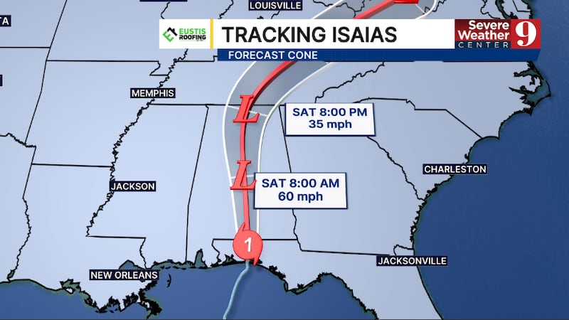
5:30 a.m. EDT | Isaias has become a post-tropical cyclone as of Saturday morning
This means it is losing its tropical characteristics, but it still has near-tropical-storm-force winds. Sustained winds remain around 35 mph.
As of this morning, it’s moving through southern Alabama.
Heavy rain will be the biggest issue across the state. Some estimates have rain totals approaching 4 to 5 inches throughout the day, particularly in some portions of Alabama.
It’s also beginning to pick up quite a bit of speed. Moving northward at 20 mph, it will continue to speed up as it weakens throughout the day.
By the end of Saturday, it will likely be crossing through middle Tennessee or south central Kentucky.
As the day progresses, the influence on central Florida will continue to die down.
This storm never had a direct impact on our area; however, we did see some of our upper-level clouds and moisture move northward following the storm.
Once the storm moves far enough away, we will see clear conditions and slightly cooler temperatures.
Friday, Oct. 9
11:00 p.m. EDT | Hurricane Isaias downgrades to a Category 1 storm
Hurricane Isaias continues to weaken as it quickly moves across the western Panhandle of Florida.
The 11 pm advisory from the National Hurricane Center reported sustained winds of 90 mph, making Isaias a Category 1 hurricane.
The storm made landfall near Destin around 9:30 pm as a Category 2 storm.

The Hurricane Warning west of the Mississippi/Alabama line has been discontinued.
Continued weakening will continue, and Isaias will likely become post-tropical by Saturday morning.
Heavy rain, high winds, and storm surge will continue for the next few hours over portions of the western Panhandle.
The tornado threat will persist overnight across the eastern Panhandle and the Big Bend region, and a Tornado Watch remains in effect until 6 am.
Isaias was the first hurricane to hit Florida since Milton impacted the Sarasota area two years ago.
10:00 p.m. EDT | Hurricane Isaias remains a Category 2 storm
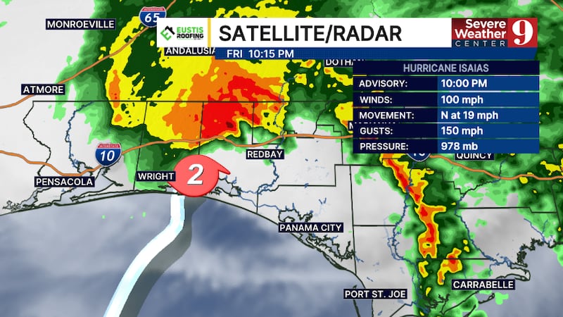
Hurricane Isaias continues to weaken as it moves into the western Panhandle of Florida.
The 10 pm update had winds of 100 mph, making Isaias a Category 2 hurricane.
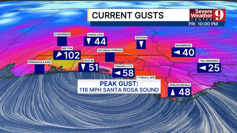
A wind gust of 102 mph has been reported in Milton.
Storm surge is also occurring and will continue throughout the high-tide cycle.
Isaias will continue to move northward toward southern Alabama over the next several hours.
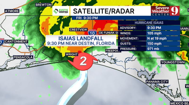
9:30 p.m. EDT | Hurricane Isaias officially makes landfall near Destin
Hurricane Isaias has made landfall near Destin, Florida.
Landfall occurred at 9:30 pm as a Category 2 hurricane with winds of 105 mph.
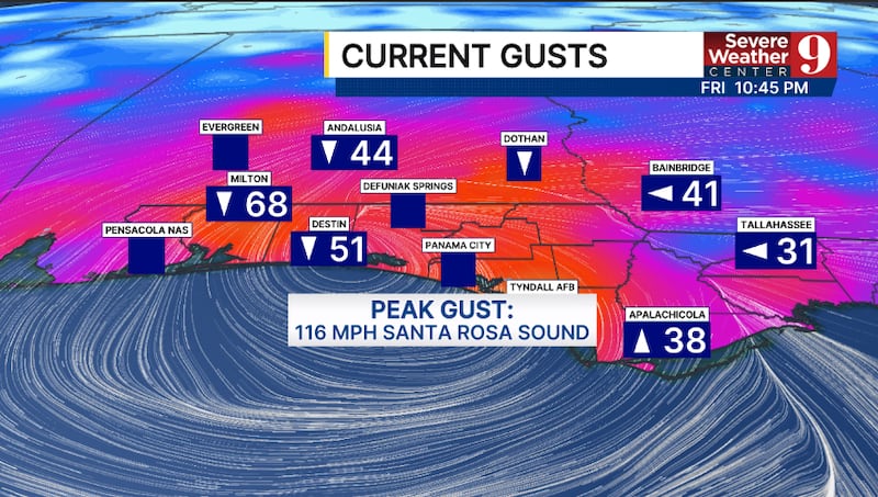
A wind gust of 116 mph has been reported near Santa Rosa Sound.
Isaias the first hurricane to make landfall in Florida since Milton hit the Sarasota area two years ago today.
9 p.m. EDT | Hurricane Isaias approaching landfall near Destin
The center of Hurricane Isaias is approaching the Destin area, with landfall expected within the next 30 to 60 minutes.
As of 9 p.m., Isaias was 50 miles south-southeast of Pensacola with maximum sustained winds of 105 mph, according to the National Hurricane Center. The storm remains a Category 2 hurricane.
An extreme wind warning remains in effect for southeastern Escambia, southern Santa Rosa and southern Okaloosa counties until 8:45 p.m. CDT, or 9:45 p.m. EDT.
Dangerous storm surge is also occurring along the coast. An estimated 5 feet of storm surge was reported near Panama City Beach.
8:30 p.m. EDT | Escambia County has issued a precautionary boil water notice after the impacts of Hurricane Isaias.
Click the link for more details
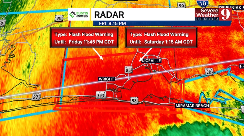
8:20 p.m. EDT | Flash flood emergency issued for southern Okaloosa County
A flash flood emergency has been issued for southern Okaloosa County, including Fort Walton Beach, Niceville and Destin.
The emergency remains in effect until 1:15 a.m. CDT, or 2:15 a.m. EDT.
Forecasters said 4 to 7 inches of rain has already fallen, and an additional 3 to 5 inches could fall within the next hour.
Life-threatening flooding is occurring or expected to begin shortly. People in the affected area should move to higher ground immediately and avoid flooded roads.
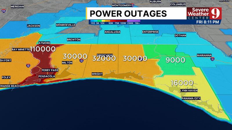
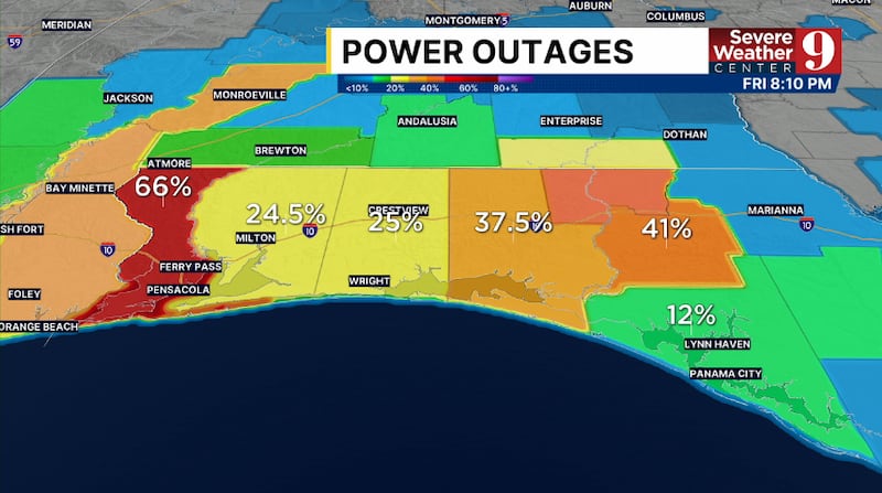
8:12 p.m. EDT |Two-thirds of Escambia County is without power

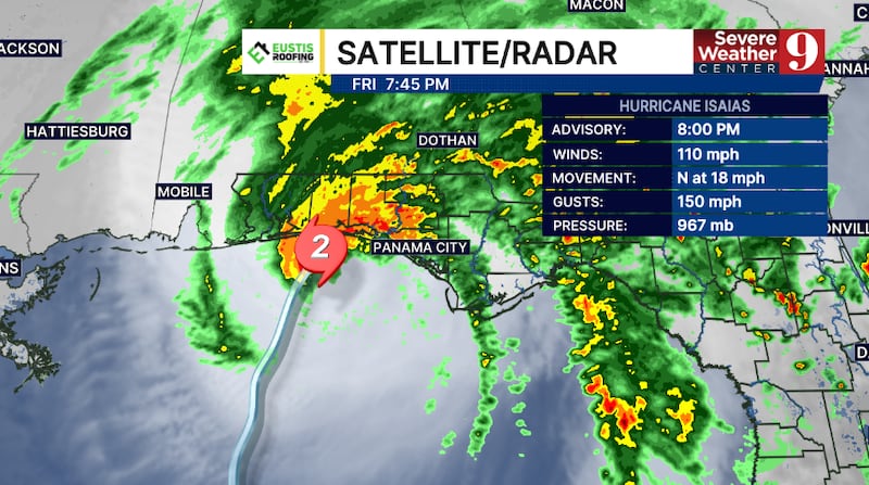
8 p.m. EDT |Hurricane Isaias has weakened to a Category 2 storm and is expected to make landfall in the next 90 minutes
Hurricane Isaias has weakened to a Category 2 storm and is nearing landfall along the western Florida Panhandle.
The 8 pm advisory from the National Hurricane Center had winds of 110 mph, making Isaias a Category 2 hurricane.
Isaias is now 45 miles southeast of Pensacola.
Some slight weakening is possible, but Isaias will likely hit as a Category 2 storm in the next 1-2 hours.
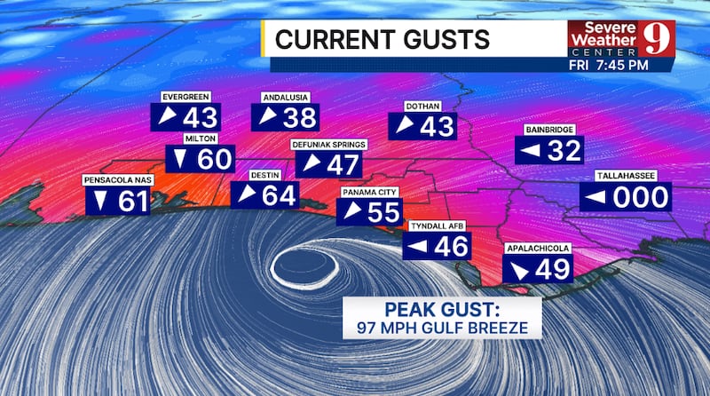
Heavy rain, extreme winds, and storm surge are now occurring along much of the western Panhandle.
The tornado threat continues, and a Tornado Watch remains in effect for much of the Panhandle and Big Bend areas until 9 pm.
Landfall is highly likely between Destin and Panama City Beach.
Central Florida Impacts
The threat for severe weather in the region is decreasing.
A Tornado Watch continues for Marion County until 9 pm, but the tornado threat is beginning to shift northward.
A few scattered showers remain possible through the late evening hours.
7 p.m. EDT | Isaias’s outer eyewall moves into the western Florida Panhandle
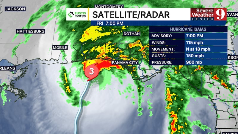
The outer eyewall of Hurricane Isaias is now moving into the western Florida Panhandle coastline.
The 7 pm update had Isaias 55 miles south-southeast of Pensacola.
Winds remain at 115 mph, keeping Isaias a Category 3 major hurricane.

An Extreme Wind Warning has been issued for southeastern Escambia, southern Santa Rosa, and southern Okaloosa counties until 8:45 pm CT.
Hurricane-force winds will overspread this area, with gusts over 100 mph likely.
6 p.m. EDT | Hurricane-force winds reach western Florida Panhandle
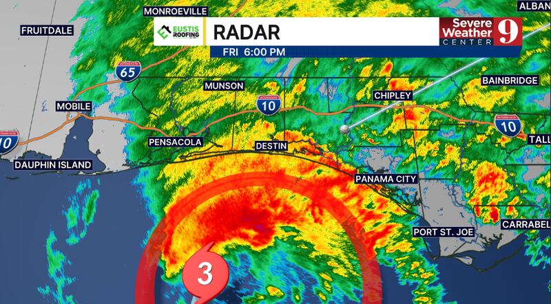
Hurricane-force winds are beginning to move into the western Florida Panhandle as Hurricane Isaias approaches landfall.
Isaias was about 70 miles south-southeast of Pensacola with maximum sustained winds of 115 mph, according to the 6 p.m. update. The storm remains a Category 3 hurricane.
A wind gust of 75 mph was recorded at Perdido Bay, Florida.
5:40 p.m. EDT | Florida stages thousands of responders ahead of landfall
Florida has activated thousands of personnel and staged equipment across the Panhandle ahead of Hurricane Isaias, according to an update from Gov. Ron DeSantis’ office.
More than 16,000 utility workers are prepared to assist with power restoration. About 5,000 Florida National Guard members and nearly 400 Florida State Guard personnel have also been activated.
The state said its preparations include:
- More than 1,300 high-wheeled vehicles, 20 boats and eight National Guard helicopters
- More than 1,100 Florida Department of Transportation workers
- About 260 pieces of heavy equipment, 1,400 generators and 100 pumps
- High-water vehicles, airboats and shallow-water vessels for rescues
- Search-and-rescue, debris-removal and road-clearance teams
Special-needs shelters are open in Bay, Escambia, Holmes, Okaloosa, Walton and Washington counties.
Pensacola International Airport, Destin-Fort Walton Beach Airport and Northwest Florida Beaches International Airport have closed to commercial service. The ports of Pensacola and Panama City have also closed operations.
State officials said bridges may close when sustained winds reach 39 mph.

5:15 p.m. EDT | Severe thunderstorm warning issued for southwestern Marion County
A severe thunderstorm warning is in effect for southwestern Marion County, including Dunnellon, through 5:45 p.m.
The storm was moving north at 20 mph. The primary threats include wind gusts exceeding 50 mph, intense lightning and hail.
A tornado watch remains in effect for Marion County through 9 p.m. Additional strong to severe storms are possible Friday evening.
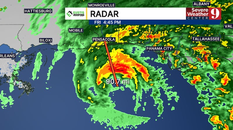
5 p.m. EDT | Hurricane Isaias nears Florida Panhandle landfall
Hurricane Isaias was approaching the western Florida Panhandle on Friday evening as conditions continued to deteriorate across the region.
The National Hurricane Center said Isaias had maximum sustained winds of 115 mph, making it a Category 3 hurricane. Its center was about 90 miles south of Pensacola.
Landfall is expected between Pensacola and Destin within the next several hours. Forecasters said some weakening remains possible before landfall, but Isaias could still reach the coast as a Category 3 hurricane.
Heavy rain, destructive winds and dangerous storm surge will intensify across the western Panhandle Friday evening. A tornado watch remains in effect for much of the Panhandle and Big Bend through 9 p.m.
Isaias will remain well west of Central Florida, but fast-moving showers and storms are possible through the evening. A tornado watch includes Marion County, including Ocala and Belleview, through 9 p.m.

4:25 p.m. EDT | Tornado watch issued for Marion County
A tornado watch is in effect for Marion County, including Ocala and Belleview, until 9 p.m.
The threat of isolated tornadoes is increasing across far northwestern portions of Central Florida as Hurricane Isaias approaches landfall in the western Panhandle.
A tornado watch means conditions are favorable for tornadoes. It does not mean a tornado has been detected. Residents should remain alert and be prepared to seek shelter if a warning is issued.
4 p.m. EDT | Conditions rapidly deteriorate in western Panhandle
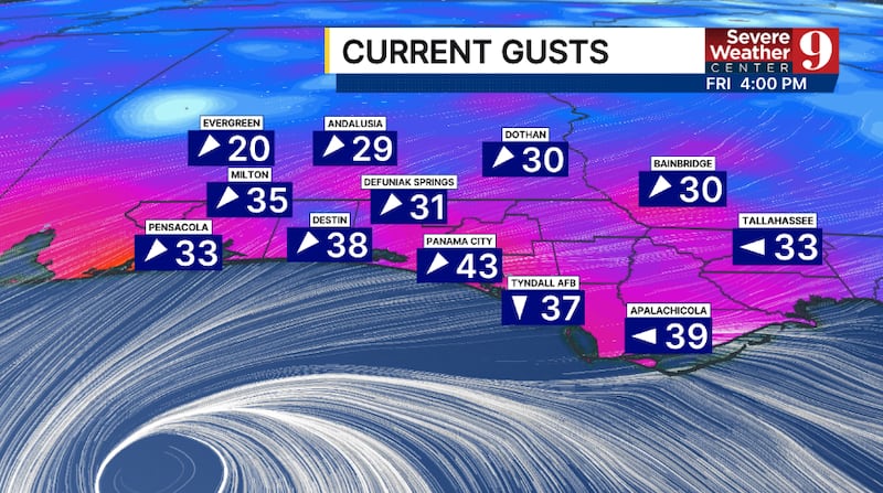
Conditions are rapidly deteriorating across Florida’s western Panhandle as Hurricane Isaias moves closer to the coast.
The center of Isaias was about 90 miles south of Pensacola in the 4 p.m. update. Maximum sustained winds remain at 120 mph, keeping Isaias a major Category 3 hurricane.
A wind gust of 47 mph was reported in Navarre Beach as tropical-storm conditions spread across the region. Other observed gusts included 43 mph in Panama City, 38 mph in Destin and 33 mph in Pensacola.
The next full National Hurricane Center advisory is scheduled for 5 p.m.
3 p.m. EDT | Tornado warning issued as Isaias nears Panhandle

Hurricane Isaias is beginning to spread tropical-storm conditions across Florida’s western Panhandle.
The center of Isaias was about 125 miles south of Pensacola in the 3 p.m. update. Maximum sustained winds remain at 120 mph, keeping Isaias a major Category 3 hurricane.
A tornado warning is in effect for southeastern Gulf County and southwestern Franklin County until 3:45 p.m.
People in the warned area should seek shelter immediately in an interior room on the lowest floor of a sturdy building, away from windows.
The next update on Hurricane Isaias is expected at 4 p.m.
2:30 p.m. EDT | Tornado watch issued as Hurricane Isaias approaches landfall
Hurricane Isaias remains a powerful Category 3 storm with maximum sustained winds of 120 mph, according to the National Hurricane Center’s 2 p.m. advisory.
Some weakening is forecast as Isaias approaches the Gulf Coast, but the hurricane could still make landfall as a Category 3 storm over Florida’s western Panhandle.
Rainbands are already affecting much of the Panhandle and are expected to become more widespread and intense Friday afternoon and evening.
A tornado watch is in effect for much of the Florida Panhandle and Big Bend until 9 p.m. Conditions within the watch area are favorable for tornadoes as Isaias approaches landfall.
Landfall remains likely between Pensacola and Destin Friday evening or shortly after midnight.
The next National Hurricane Center update is scheduled for 3 p.m.
2:15 p.m. EDT | Hurricane Isaias closes in on Gulf Coast
Hurricane Isaias remains a Category 3 storm with maximum sustained winds of 120 mph as it moves toward the northern Gulf Coast.
The National Hurricane Center said life-threatening storm surge and destructive winds are likely along portions of the Florida Panhandle and Alabama coasts. The center of the storm is expected to reach the western Florida Panhandle coast Friday evening.
Channel 9 crews are in Pensacola and Perdido Key to document preparations and changing conditions ahead of landfall.
1 p.m. EDT | Isaias about 160 miles south of Pensacola
The center of Hurricane Isaias was about 160 miles south of Pensacola during the National Hurricane Center’s latest position update.
Isaias had maximum sustained winds of 120 mph and was moving north-northeast at 16 mph. Its minimum central pressure remained at 959 millibars.
A hurricane warning remains in effect from Ocean Springs, Mississippi, to the Bay-Gulf county line in Florida.
A storm surge warning extends from the mouth of the Mississippi River to the Suwannee River. Tropical storm warnings cover areas on either side of the hurricane warning.
Noon EDT | Saildrone records 104 mph gust near Isaias’ eyewall
A NOAA Saildrone positioned near the eyewall of Hurricane Isaias recorded a wind gust of 104 mph, according to the National Hurricane Center.
Hurricane-force winds extended up to 30 miles from the center, while tropical-storm-force winds extended up to 185 miles.
10 a.m. EDT | Escambia County prepares for dangerous storm surge
Officials warned that storm surge could reach 6 to 9 feet above ground in affected coastal areas from the Alabama-Florida border to Grayton Beach.
Escambia County ordered evacuations for Zones A and B, including Pensacola Beach. Officials warned that emergency responders may be unable to answer calls once sustained winds reach 39 mph or storm surge covers roads.
Residents can check their Escambia County evacuation zone here.
8:30 a.m. EDT | DeSantis warns of storm surge and wind damage
Gov. Ron DeSantis provided an update from Pensacola as officials prepared for Hurricane Isaias.
DeSantis urged residents in evacuation zones to follow local orders and warned that storm surge posed one of the greatest threats to life and property. Florida previously declared a state of emergency for 25 counties.
7:20 a.m. EDT | Isaias strengthens into a major hurricane
Hurricane Hunter aircraft found that Isaias had strengthened into a Category 3 hurricane with maximum sustained winds of 120 mph.
The milestone made Isaias the first major hurricane of the 2026 Atlantic season.
Click here to download our free news, weather and smart TV apps. And click here to stream Channel 9 Eyewitness News live.

©2026 Cox Media Group