
ORLANDO, Fla. — Significant flash flooding is affecting Brevard County Thursday, with water entering homes, rescues reported and mandatory evacuations underway in part of Palm Bay Estates.
Brevard County is under a rare Level 4 High Risk for excessive rainfall, the Weather Prediction Center’s highest category. Additional rain could worsen flooding through the afternoon.
Watch live team coverage on Channel 9 and MagicTV 27
Latest forecast | Palm Bay evacuations and road closures | Sandbag locations | Send photos and video
Thursday afternoon update as southeastern Brevard flood warning continues until 6 p.m.
A flood warning is in effect for southeastern Brevard County until 6 p.m. Thursday.
Little additional heavy rain is forecast through that time, but runoff from earlier downpours and high river and stream levels are prolonging flooding impacts.
Locations listed in the warning include Palm Bay, Melbourne, West Melbourne, Malabar, Indialantic, Melbourne Beach, Grant-Valkaria, Barefoot Bay and Micco.
Residents should remain cautious even as rainfall eases. Never drive through floodwater or around barricades.
Read Palm Bay Estates evacuation instructions and reported road closures and watch Channel 9’s live coverage.

1 p.m. update as rain eases but significant flooding continues
Significant flooding continues in central and southern Brevard County, with water entering homes and evacuations underway in some neighborhoods.
Rainfall intensity is decreasing along the coast, but significant flooding will persist into the afternoon.
As of 1 p.m., flash flood warnings remain in effect for:
- Central Brevard County until 2:45 p.m.
- Southeastern Brevard County until 1:45 p.m.
- Eastern Orange County until 1:15 p.m.
- Southeastern Volusia County, including Daytona Beach, until 1:15 p.m.
Brevard County remains under a rare Level 4 High Risk for excessive rainfall for the rest of Thursday. Catastrophic flooding is possible.
A Level 3 risk remains in place for other portions of the coast, eastern Orange and eastern Osceola counties.
Read evacuation instructions for Palm Bay Estates and watch Channel 9’s live team coverage.
Never drive through floodwater or around barricades. Follow instructions from emergency personnel.
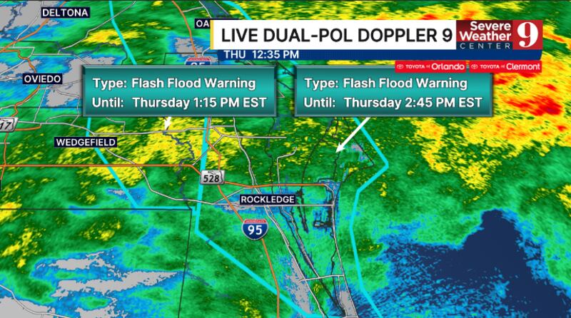
12:38 p.m. Thursday update as central Brevard warning is extended
A flash flood warning for central Brevard County has been extended until 2:45 p.m., including Melbourne, Titusville, Rockledge, Cocoa and Viera.
Doppler radar estimates 7–11 inches of rain have fallen in the warned area. An additional 2 inches is possible.
Significant flash flooding has been reported, including water entering homes and water rescues. Significant flooding remains possible through mid-afternoon.
Brevard County remains under a Level 4 High Risk for excessive rainfall for the rest of Thursday.
Follow Severe Weather Center 9’s latest forecast and warning updates.
Mandatory evacuations underway in part of Palm Bay Estates
Palm Bay has ordered mandatory evacuations for residents of Palm Bay Estates west of the canal and east of the railroad tracks. Voluntary evacuations apply to the rest of the community.
Police and firefighters are assisting residents by boat. The city said residents will be transported to the Captain’s House, where arrangements will be made to relocate them to a shelter.
Residents in the mandatory evacuation area should follow emergency personnel’s instructions and prepare to leave immediately.
Read the evacuation instructions and Palm Bay’s reported road closures.
Shelter opens at Walter Butler Community Center in Cocoa
Brevard County has opened a shelter at Walter Butler Community Center, 4201 N. Cocoa Blvd., Cocoa, for residents affected by flooding.
Residents going to the shelter should bring their own supplies, including:
- Bedding, folding chairs or sleeping bags
- Needed medications
- Changes of clothing and sturdy shoes
- Personal hygiene items
- Books, cards, games or other entertainment
Follow evacuation instructions and avoid driving through flooded roads to reach a shelter.
Brevard schools extend closures through Friday
All Brevard Public Schools campuses and district offices will remain closed Friday, Nov. 20, as flooding continues.
Schools and offices will remain closed next week for Thanksgiving break. Students and employees are scheduled to return Monday, Nov. 30.
Read the full Brevard school closure announcement.
Volusia schools also closed Thursday and Friday
Volusia County Schools and district offices are closed Thursday and Friday.
The closure includes Extended Day Enrichment Programs, athletics, extracurricular activities and district events. Classes are scheduled to resume Monday, Nov. 30, following Thanksgiving break.
Read Volusia County Schools’ closure details.
Watch LIVE team coverage on Channel 9 and MagicTV 27
11:30 a.m. update:
The Weather Prediction Center has upgraded Brevard County to a rare Level 4 High Risk for Flash Flooding.
Significant flash flooding continues in central Brevard County and will likely continue through the daytime hours.

A Level 4 threat means widespread flash flooding is expected, with potentially catastrophic flooding possible.
A Level 4 is the highest risk of flooding and is rarely issued.
This is a potentially dangerous situation in Brevard County.
Brevard County has opened a shelter due to flooding.
The shelter is open for residents at Walter Butler Community Center, 4201 N Cocoa Blvd, Cocoa.
Residents going to shelters will need to take their own supplies, including bedding, folding chairs, or sleeping bags; any needed medications; multiple changes of clothing and and sturdy shoes; personal hygiene items; and entertainment items, like games, cards, books or magazines.
10:15 a.m. update:
Flash Flood Warning has been issued for eastern Orange County until 11:15 am.
Flash Flood Warning continues for Central Brevard until 12:45 pm, and for southeastern Brevard until 11:45 am.
READ: Where to get sandbags in Central Florida as heavy rain raises flooding concerns

Doppler radar continues to estimate 6 to 10 inches of rain has fallen in central Brevard.
Significant flooding continues in parts of this area.
The band of rain continues to lift into Volusia, and the flooding threat will increase in the next 1-2 hours.
A Level 3 flood risk remains in place for much of the coast, eastern Orange and eastern Osceola counties for the rest of today.
9:05 a.m. update:
Flash Flood Warning continues for central and southeastern Brevard County until 9:45 a.m.
Significant street flooding is now being reported in parts of Port St. John.
Doppler radar estimates 6 to 10 inches of rain have fallen in central Brevard County.
Significant flooding is occurring in parts of this area.
Heavy rainfall continues in southeastern Brevard County, with the flooding threat increasing.
The band of rain is now lifting into southeastern Volusia, and the flooding threat will be increasing in the next 1-2 hours.
A Level 3 flood risk remains in place for much of the coast, eastern Orange and eastern Osceola counties for the rest of today.
8:13 a.m. update:
Flash Flood Warning has been extended for Central Brevard until 9:45 am.
Flash Flood Warning continues for Southeastern Brevard until 9:45 am. This includes Palm Bay.
Doppler radar now estimates 6 to 10 inches of rain has fallen in Central Brevard.

Significant flooding is likely occurring in parts of this area.
Another strong rain band is pushing in from the Atlantic. Heavy rain and winds of 50-55 mph are possible over the next 30 minutes.
A Level 3 flood risk remains in place for much of the coast, eastern Orange and eastern Osceola counties for the rest of today.
7:55 a.m. update:
The mayor of Titusville has issued a local state of emergency.
7:15 a.m. update:
A new Flash Flood Warning has been issued for southeastern Brevard County until 9:45 am. This includes Palm Bay.
Flash Flood Warning continues for Central Brevard until 7:45 am.
Water has been reported entering homes near Anderson Elementary in Rockledge.
Flooding could become significant in this area through mid-morning.
A significant rain band is currently moving through much of central and southern Brevard County.
A Level 3 flood risk remains in place for much of the coast, eastern Orange and eastern Osceola counties for the rest of today.

6:45 a.m. update:
Parts of Brevard County have already received inches of rain Thursday morning.
Sharps, Cocoa, and Cocoa Beach have all received more than 6 inches of rain.

6 a.m. update:
The Flash Flood Warning continues for central Brevard County until 7:45 am.
Flooding could become significant in this area over the next 1-2 hours.
A significant rain band will rapidly increase flooding concerns in South Patrick, Melbourne and Viera.
A Level 3 flood risk remains in place for much of the coast, eastern Orange and eastern Osceola counties for the rest of today.
Original report:
Rain is expected to persist through Thursday, with the greatest danger for flooding near the coast.
Across the region, total rainfall is anticipated to reach two to six inches for inland locations, 4 to 8 inches for Metro Orlando and 8 to 14 inches for coastal zones.
Some coastal areas could see rainfall totals exceeding 14 inches.
Friday will bring a continuation of heavy rain and flood risks as a coastal system forms to the southeast.
On Saturday, the storm system is projected to move north, potentially evolving into a subtropical or tropical system.
The storm’s specific path will determine conditions, creating a growing probability of rain and powerful winds.
By Sunday, the system will exit the region, resulting in a return to drier weather.
Click here to download our free news, weather and smart TV apps. And click here to stream Channel 9 Eyewitness News live.

©2026 Cox Media Group