
ORLANDO, Fla. — Hurricane Isaias has strengthened into a Category 2 storm as of Thursday evening and is forecast to make landfall near the Alabama-Florida border late Friday or early Saturday.
The storm is not headed toward Central Florida, but its effects could eventually be felt through property insurance rates across the state.
5: 07 p.m. update:
Isaias is now a Category 2 hurricane in the 5 pm NHC advisory.
Winds are now at 100 mph.
A full update will be released soon. Stay tuned with Channel 9.
2 p.m. update:
Hurricane Isaias continues to strengthen as it moves toward the northern Gulf Coast.
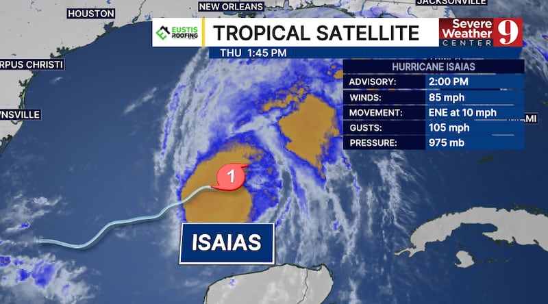
The National Hurricane Center said Isaias had maximum sustained winds of 85 mph, making it a Category 1 hurricane. The storm is forecast to become a Category 2 hurricane Thursday evening.
Hurricane warnings remain in effect for portions of the Gulf Coast, including the western Florida Panhandle. Tropical storm warnings extend across the remainder of the Panhandle to near Apalachee Bay.
Isaias is expected to make landfall near the Alabama-Florida border late Friday or early Saturday.
Animal advocates urge pet owners to prepare for Hurricane Isaias
11 a.m. update:
Hurricane Isaias strengthened Thursday morning as the National Hurricane Center moved up its projected landfall timeline.
Isaias now has maximum sustained winds of 85 mph, with gusts reaching 105 mph. The Category 1 hurricane is moving east-northeast at 10 mph.
Landfall along the northern Gulf Coast is now expected around 8 or 9 p.m. Friday, several hours earlier than previously forecast.
Isaias is forecast to strengthen into a Category 2 hurricane, with winds potentially reaching 110 mph Friday morning before the storm approaches the coast.
The storm is not headed toward Central Florida, but fast-moving showers, isolated storms and a risk of isolated tornadoes remain possible locally.
10:55 a.m. update:
Hurricane Isaias strengthened Thursday morning as residents along the Florida Panhandle and the coastlines of Alabama and Mississippi prepared for high winds, heavy rain and dangerous storm surge.
Isaias had maximum sustained winds of 80 mph with gusts reaching 100 mph. The storm was moving east-northeast at 9 mph with a minimum central pressure of 975 millibars.
The hurricane is expected to turn north later Thursday and strengthen into a Category 2 storm, potentially producing sustained winds of more than 100 mph.
The current forecast takes Isaias toward the north-central Gulf Coast, with landfall expected late Friday. One trusted forecast model brings the storm ashore around 9 p.m., but dangerous conditions will begin hours earlier.
Hurricane and storm surge warnings have been issued for coastal Alabama and portions of the western Florida Panhandle.
The affected areas could experience:
- Winds ranging from 74 to 110 mph
- A storm surge of 5 to 7 feet
- Between 3 and 6 inches of rain
Isaias is not headed directly toward Central Florida.
Channel 9 meteorologist Kassandra Crimi said Thursday’s rain across Central Florida is not connected to the hurricane.
The storm will begin influencing the area Friday. Fast-moving showers and isolated thunderstorms will be possible Friday through Sunday, along with the possibility of isolated tornadoes.
Rain coverage is expected to remain more limited than it has been during the past several days.
7:30 a.m. update:
Residents in the Florida Panhandle and coastlines of Alabama and Mississippi continue to prepare for heavy rain, high winds, and dangerous storm surge as Isaias aims for the North Central Gulf Coast.
Heavy rain will start Friday evening, with landfall expected late Friday.
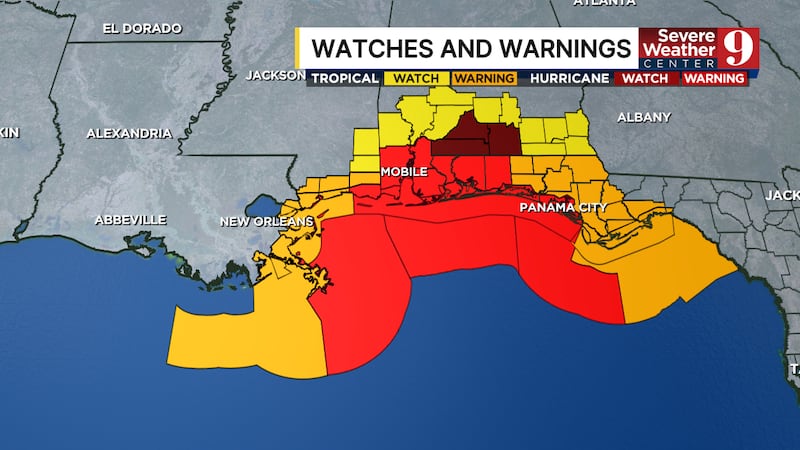
Hurricane Warnings have been issued for coastal Alabama and western portions of the Florida Panhandle.
These areas could experience winds around 74 to 110 mph and storm surge of 5 to 7 ft, along with 3 to 6 inches of rainfall.
Original report:
Isaias has strengthened into a hurricane overnight as it moves east-northeast across the Gulf, according to the National Hurricane Center.
Air Force Reserve Hurricane Hunter aircraft investigating the storm found maximum sustained winds of 75 mph, making Isaias a Category 1 hurricane.
The storm’s minimum pressure has also fallen, another indication that the system is strengthening
NHC said multiple Hurricane Hunter aircraft are investigating Isaias as it moves east-northeastward, with additional strengthening expected on Thursday.
As of early Thursday morning, Isaias was moving east-northeast at about 9 mph.
The latest forecast calls for Isaias to make landfall along the northern Gulf Coast late Friday or early Saturday.
Hurricane warnings are in effect from Ocean Springs, Mississippi, to the Bay/Gulf County line in Florida.
NHC is forecasting significant storm surge along portions of the Gulf Coast.
Surge of 5 to 7 feet is possible from Ocean Springs to Indian Pass, Florida, including Mobile Bay.
Heavy rain and flooding will also be concerns as Isaias approaches the coast and moves inland.
Channel 9 will continue to follow any updates to Hurricane Isaias and provide continuing coverage on Eyewitness News.
Click here to download our free news, weather and smart TV apps. And click here to stream Channel 9 Eyewitness News live.

©2026 Cox Media Group