
ORLANDO, Fla. — Channel 9 is monitoring the threat of flash floods in communities around Central Florida on Friday.
Watch LIVE team coverage on Channel 9 and MagicTV 27
12:48 p.m. update:
A Flash Flood Warning has been extended for eastern Flagler County until 3:30 pm.
This includes Palm Coast, Flagler Beach and Bunnell.
Doppler radar estimates that between 1 and 3 inches of rain have fallen in this area.
An additional 1 to 3 inches of rain is possible in the warned area.
Flash flooding is ongoing and is expected in this area.
Flagler County is now in a Level 4 High Risk for flash flooding today.

A Flash Flood Warning has also been extended for northeastern Volusia County until 2:30 pm.
This includes Daytona Beach, Port Orange and Ormond Beach.
Doppler radar estimates that between 3 and 5 inches of rain have fallen in this area.
An additional 2 inches of rain is possible in the warned area.
Flash flooding is ongoing, with water rescues underway in the Midtown section of Daytona Beach.
Significant flash flooding remains likely.
Volusia County remains in a Level 4 High Risk for flash flooding today.
10:17 a.m. update:
A Flash Flood Warning has been extended for northeastern Volusia County until 12:30 p.m.
This includes Daytona Beach, Port Orange and Ormond Beach.
Doppler radar estimates that between 3 and 5 inches of rain have fallen in this area.
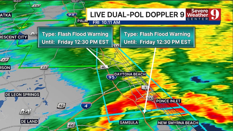
An additional 2 to 3 inches of rain is possible in the warned area.
Flash flooding is ongoing and is expected in this area. Significant flash flooding is possible.
Volusia County remains in a Level 4 High Risk for flash flooding today.
8:45 a.m. update:
The National Weather Service in Melbourne issued a flash flood warning Friday morning for parts of east central Florida, including northern Brevard County, northeastern Seminole County and southeastern Volusia County.
The warning is scheduled to remain in effect until 12:30 p.m., after Doppler radar indicated showers and thunderstorms producing heavy rain across the region.
Between 2 and 3 inches of rain had already fallen by 8:30 a.m., and the weather service reported that an additional 2 to 4 inches of rainfall is possible.
According to the weather service, flash flooding is ongoing or expected to develop shortly.
The deluge threatens to flood small creeks and streams, urban neighborhoods, highways, streets and underpasses, along with other low-lying spots and areas with poor drainage.
Locations expected to experience flash flooding include Port Orange, New Smyrna Beach, Edgewater, Oak Hill, Bethune Beach, Apollo Beach and Ponce Inlet.
The weather service listed additional affected areas including Maytown, Glencoe, Farmton, Turtle Mound, Lake Ashby, Eldora, Shiloh, Samsula-Spruce Creek and New Smyrna Beach Airport.
Original report:
Northern Brevard County residents are waking up under another flash flood warning early this morning as persistent heavy rain continues to soak the area.
The National Weather Service has a flash flood warning in effect until 6 a.m. for northern Brevard County.
Between 1 and 2.5 inches of rain has already fallen, with an additional 1 to 2 inches expected through 6 a.m.
Forecasters say the region remains at a Level 4 risk for heavy rain, meaning additional pockets of intense rainfall are likely throughout the day.
That elevates the threat of localized flooding, especially in low-lying areas, near canals, and along roadways prone to rapid water accumulation.
Residents are urged to avoid driving through standing water, monitor rising levels in drainage areas, and stay tuned to local updates as conditions evolve.
More heavy rain could bring further impacts later Friday.
Click here to download our free news, weather and smart TV apps. And click here to stream Channel 9 Eyewitness News live.

©2026 Cox Media Group